

You can find on this page the South Africa geographical map to print and to download in PDF. The South Africa geographic map presents the topography, elevation, rivers, mountains, climate and physical features of South Africa in Africa.
The South Africa physical map shows landform and geography of South Africa. This geographical map of South Africa will allow you to discover physical features of South Africa in Africa. The South Africa physical map is downloadable in PDF, printable and free.
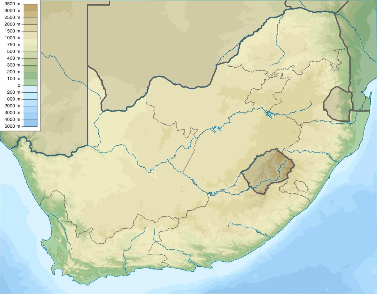
Like much of the African continent, South Africa physical landscape is dominated by a high plateau in the interior, surrounded by a narrow strip of coastal lowlands. Unlike most of Africa, however, the perimeter of South Africa inland plateau rises abruptly to form a series of mountain ranges before dropping to sea level. These mountains, known as the Great Escarpment, vary between 2,000 meters and 3,300 meters in elevation as its mentioned in South Africa physical map. The coastline is fairly regular and has few natural harbors. Each of the dominant land features—the inland plateau, the encircling mountain ranges, and the coastal lowlands—exhibits a wide range of variation in topography and in natural resources.
South Africa interior physical plateau consists of a series of rolling grasslands (veld in Afrikaans), arising out of the Kalahari Desert in the north as you can see in South Africa physical map. The largest sub-region in the plateau is the 1,200-meter to 1,800-meter-high central area known as the Highveld. The Highveld stretches from Western Cape Province to the northeast, encompassing the entire Free State (formerly the Orange Free State). In the north it rises into a series of rock formations known as the Witwatersrand (literally, "Ridge of White Waters" in Afrikaans, commonly shortened to Rand). The Rand is a ridge of gold-bearing rock, roughly 100 kilometers by thirty-seven kilometers, that serves as a watershed for numerous rivers and streams. It is also the site of the world's largest proven gold deposits and the country leading industrial city, Johannesburg.
Most of South Africa physical landscape is made up of high, flat areas called plateaus. These lands are covered with rolling grasslands, called highveld, and tree-dotted plains called bushveld. To the east, south, and west of the plateau lands is a mountainous region called the Great Escarpment. The eastern range, called the Drakensberg, or Dragon Mountain, is filled with jagged peaks, some more than 11,400 feet (3,475 meters) high as you can see in South Africa physical map.
South Africa topographic map shows the physical features of South Africa. This topographical map of South Africa will allow you to discover landforms and geographical of South Africa in Africa. The South Africa topographic map is downloadable in PDF, printable and free.
South Africa occupies the southern tip of Africa, its coastline stretching more than 2,500 km (1,553 mi) from the desert border with Namibia on the Atlantic (western) coast southwards around the tip of Africa and then north to the border with Mozambique on the Indian Ocean as its shown in South Africa topographic map. The low-lying coastal zone is narrow for much of that distance, soon giving way to a mountainous escarpment (Great Escarpment) that separates the coast from the high inland plateau. In some places, notably the province of KwaZulu-Natal in the east, a greater distance separates the coast from the escarpment. Although most of the country is classified as semi-arid, it has considerable variation in climate as well as topography.
Within Africa vast borders are many topographical features, such as deserts, mountains, plateaus, and rivers. In this lesson, students will study some of Africa diverse landscape and investigate how these features impact the available water supply, food sources, and population distribution of this unique continent as its mentioned in South Africa topographic map. Three countries are highlighted in different locations with distinctive landforms: Algeria in North Africa, Ethiopia in East Africa, and the country of South Africa. From the Sahara Desert to the Great Rift Valley to the South African veld, students will compare topographical features and their effect on each country physical and human environments.
South Africa has a mean altitude of about 1,200 m (3,900 ft), and at least 40% of the surface is at a higher elevation. Parts of Johannesburg are more than 1,800 m (6,000 ft) above sea level as you can see in South Africa topographic map. There are three major zones: the marginal regions, which range in width from 80 to 240 km (50–150 mi) in the east to 60–80 km (35–50 mi) in the west, and including the eastern plateau slopes, Cape folded belt, and western plateau slopes; a vast saucershaped interior plateau, separated from the marginal zone by the Great Escarpment; and the Kalahari Basin, only the southern part of which projects into north-central South Africa.
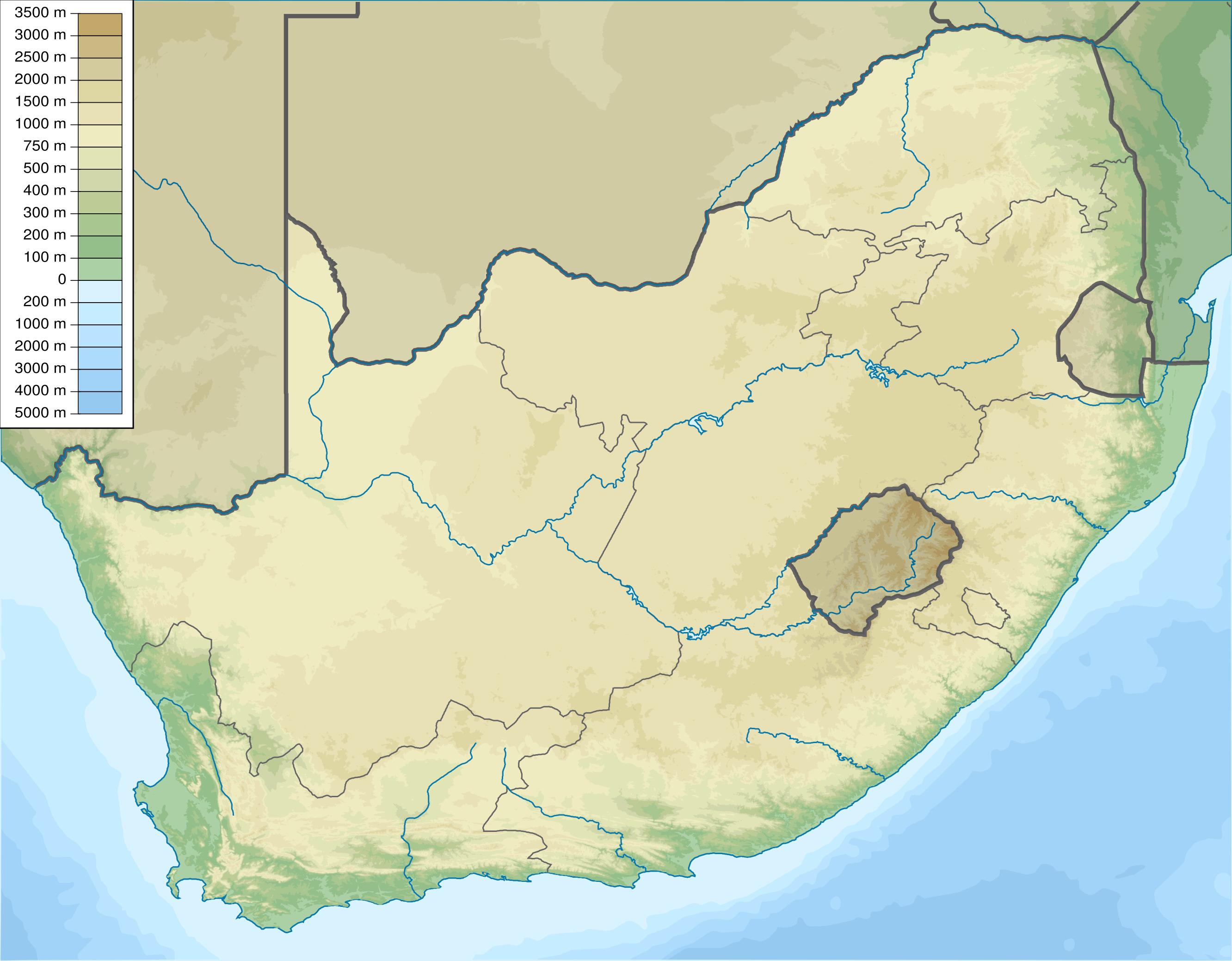
The South Africa elevation map shows the different altitudes of South Africa. This altitude map of South Africa will allow you to know where are the highest and lowest regions of South Africa in Africa. The South Africa elevation map is downloadable in PDF, printable and free.
The highest peaks in the nation not part of the Drakensberg Escarpment are located in the Karoo range in the southwestern part of the country of South Africa as its shown in South Africa elevation map. The two highest peaks in the Karoo are Compassberg and Seweweekspoortpiek, with summit elevations of 2,504 metres (8,215 ft) and 2,325 metres (7,628 ft) respectively.
North of the Witwatersrand is a dry savanna subregion, known as the Bushveld, characterized by open grasslands with scattered trees and bushes. Elevation varies between 600 meters and about 900 meters above sea level as its mentioned in South Africa elevation map. The Soutpansberg range reaches an elevation of 1,700 meters before dropping off into the Limpopo River Valley and the border between South Africa and Zimbabwe. West of the Bushveld is the southern basin of the Kalahari Desert, which borders Namibia and Botswana at an elevation of 600 meters to 900 meters.
Mafadi is a peak on the border of South Africa and Lesotho. At a height of 3,450 metres (11,300 ft), it is the highest mountain in South Africa, but is lower than Thabana Ntlenyana, the highest peak in Lesotho which is, at 3,482 metres (11,420 ft), the highest point in Southern Africa. Mafadi lies at S 29 12 08.4 E 29 21 25.5 in the WGS84 format as you can see in South Africa elevation map.

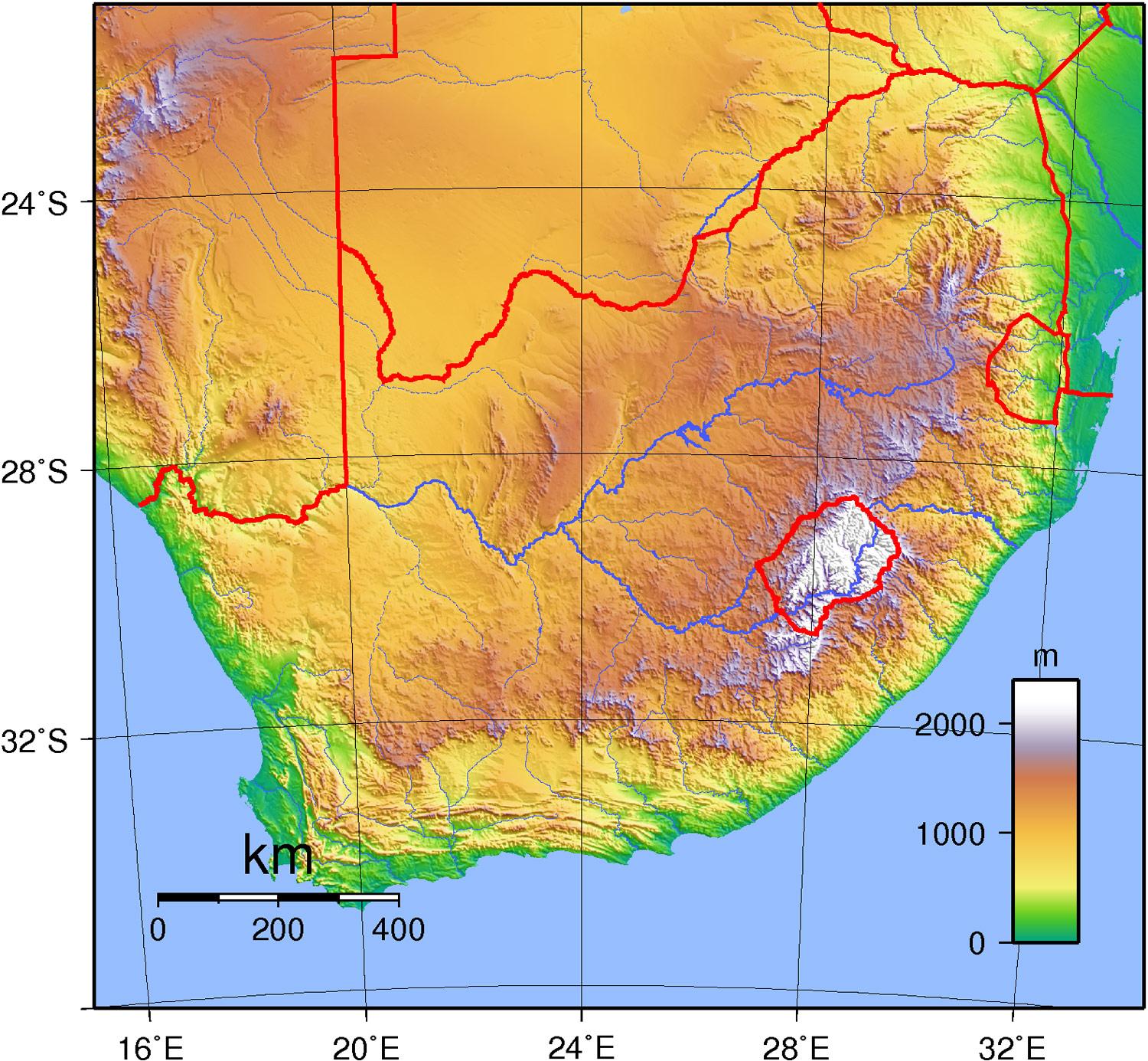
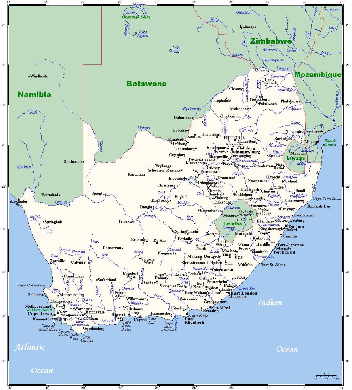
The rivers in South Africa map shows the principal rivers with their names of South Africa. The rivers map of South Africa will allow you to find the main rivers which flow in and through South Africa in Africa. The South Africa rivers map is downloadable in PDF, printable and free.
The two most important rivers draining the interior plateau are the Orange (with its tributary the Vaal), which flows into the Atlantic Ocean, and the Limpopo, which empties into the Indian Ocean through Mozambique as its shown in South Africa rivers map. Of the fast-flowing rivers with steeply graded courses that produce spectacular waterfalls, the largest is the Tugela, which rises in the Mont-aux-Sources and flows swiftly to the Indian Ocean.
The Orange River is the largest and longest river in South Africa. It rises in the Drakensberg in the east (near Mont-Aux-Sources) and flows westward across the full breadth of the RSA as its mentioned in South Africa rivers map. Its mouth is at Oranjemund along the west coast. The Orange River forms quite a number of borders, of which the most important is the border between the RSA and Namibia. The Gariep Dam was built in the upper courses of the Orange River to store water for the dry periods of the year. Thus the water is used mainly for irrigation, but the dam is also an important source of hydro-electric power.
The Limpopo rises near Johannesburg, where it is called the Crocodile River. Just after it is joined by the Great Marico tributary, it is called the Limpopo. Another important tributary is the Olifants River as you can see in South Africa rivers map. The Limpopo first forms the border between the RSA and Botswana, and later also between the RSA and Zimbabwe. It then flows through Mozambique, where it ultimately flows into the Indian Ocean. The rivers to the northeast, which rise in the Drakensberg escarpment, are the Komati, Pongola, Tugela, Great Kei and Keiskamma Rivers. Lower down there are the Sundays, Great Fish, Gamtoos, Gouritz and Breede Rivers. The Berg and Olifants Rivers flow along the west coast.
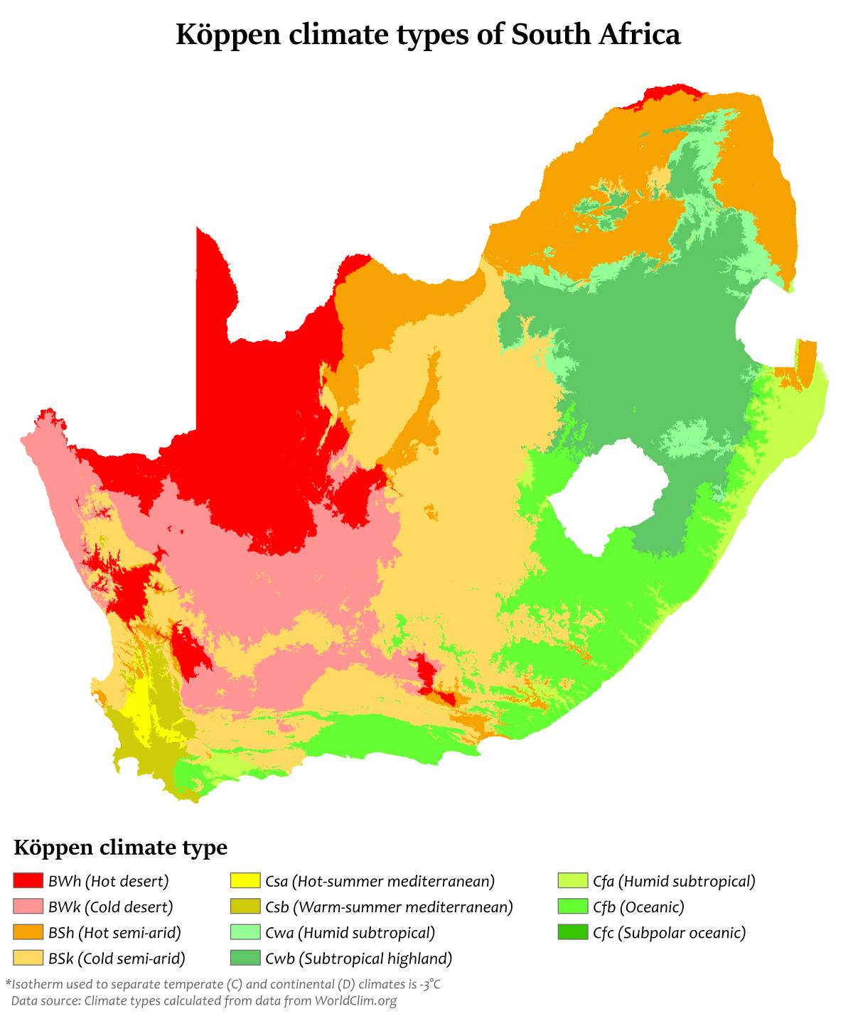
The South Africa climate map shows average temperature and climate zones of South Africa. This climate map of South Africa will allow you to know weather, average precipitation, average sunshine and different climates of South Africa in Africa. The South Africa climate map is downloadable in PDF, printable and free.
The Karoo, which occupies a large part of the western Central Plateau, has a climate extremely hot in summer and bitterly cold in winter. In contrast, the eastern coastline on the Indian Ocean is lush, well watered and warmed by the Mozambique Current; patches of Southern Africa mangroves grow along this coast. The southern coast, part of which is known as the Garden Route, is temperate and green as its shown in South Africa climate map. The Cape of Good Hope has a Mediterranean climate, with cool, wet winters and warm, dry summers (becoming hotter in interior valleys).
Snow commonly falls in winter on the higher ground of the Cape Fold Mountains. The Cape has a reputation for its wind - which blows intermittently virtually all year round, either from the south-east or the north-west - and for its sunny summer, when almost no rain falls. The vegetation of the Cape area consists of fynbos grassland and Albany thickets. The eastern section of the Karoo does not extend as far north as the western part, giving way to the flat landscape of the Free State, which though still semi-arid receives somewhat more rain as its mentioned in South Africa climate map. North of the Vaal River the Highveld is better watered, its annual rainfall is 760 mm (29.9 in) and due to its high altitude (around 1,750 m/5,741 ft) is saved from extremes of heat. Winters are cold, though snow is rare.
Further north and to the east of South Africa, especially where a drop in altitude beyond the escarpment gives the Lowveld its name, temperatures rise: the Tropic of Capricorn slices through the extreme north. Here one finds the typical South African Bushveld. There is skiing in winter in the high Drakensberg mountains that form the eastern escarpment, but the coldest place in the country is Sutherland in the western Roggeveld Mountains, with midwinter temperatures as low as −15 degrees Celsius. The deep interior provides the hottest temperatures: in 1948 the mercury hit 51.7 °C (125.06 °F) in the Northern Cape Kalahari near Upington as you can see in South Africa climate map.