

You can find on this page the South Africa cities map to print and to download in PDF. The South Africa map city presents main cities, towns and presents the capital of South Africa in Africa.
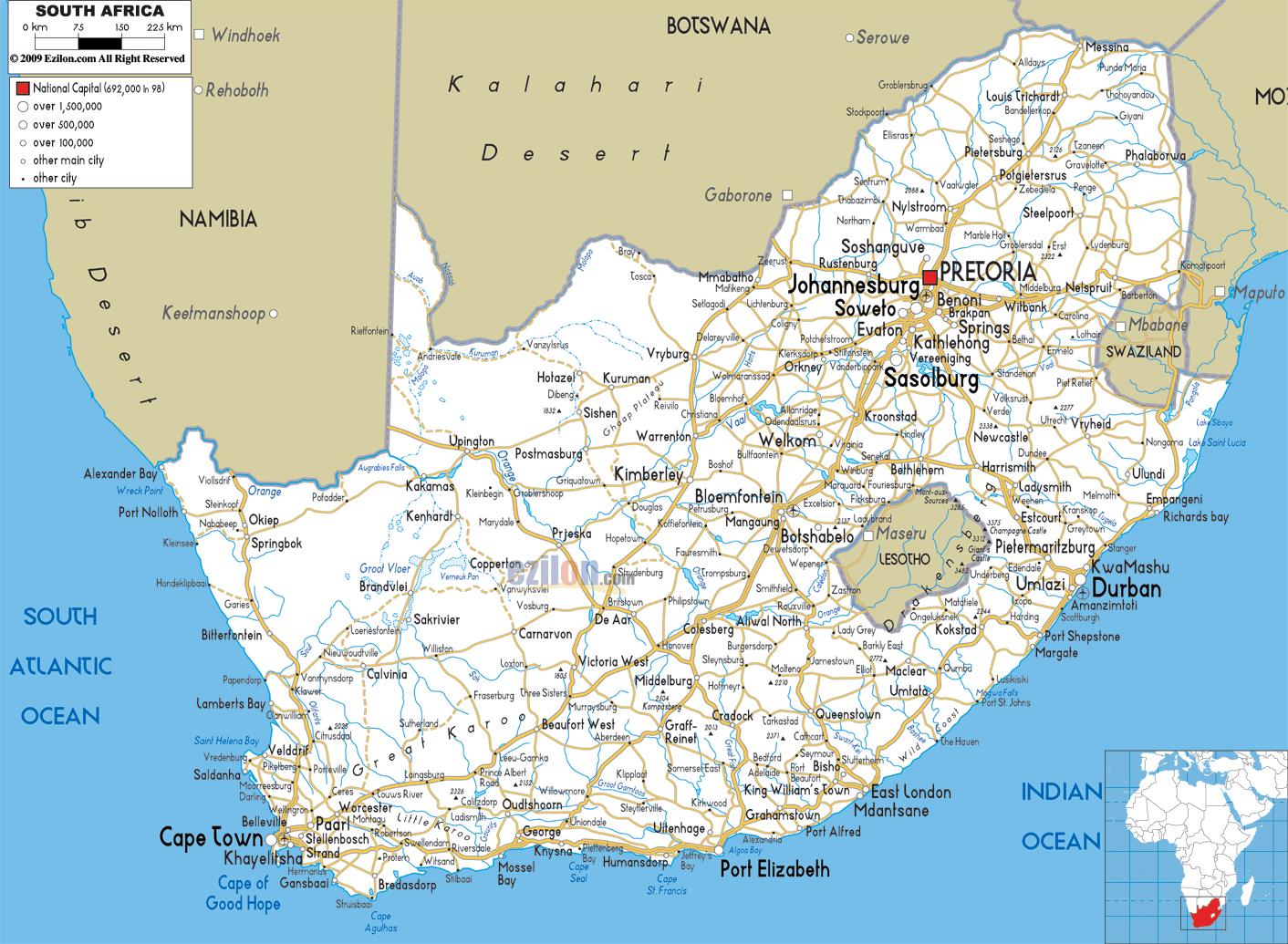
The map of South Africa with cities shows all big and medium towns of South Africa. This map of cities of South Africa will allow you to easily find the city where you want to travel in South Africa in Africa. The South Africa cities map is downloadable in PDF, printable and free.
South Africa Cities as its mentioned in the map of South Africa with cities are: Alexandria, Beaufort West, Bisho, Bloemfontein, Calvina, Cape Town, De Aar, Dundee, Durban, East London, Golela, Hotazel, Johannesburg, Kimberley, Klerksdorp, Knysna, Kroonstad, Ladysmith, Lephalale (Ellisras), Lichtenburg, Mafikeng, Middelburg, Mokopane (Portgietersrus), Mosselbaai, Musina (Messina), Nelspruit, Nylstroom, Pietermaritzburg, Polokwane (Pietersburg), Port Elizabeth, Port Nolloth, Port Shepstone, Pretoria, Queenstown, Richards Bay, Rustenburg, Saldanha, Sishen, Springbok, Standerton, Stanger, Swellendam, Ulundi, Umtata, Upington, Vanrhynsdorp, Vereeniging, Vryburg, Witbank and Worcester.
The best cities in South Africa have a wealth of things to see and do, and visitors will be delighted with its fantastic range of outdoor activities, as well as the plethora of restaurants, bars and accommodation options which combine to make it an easy and exciting country to travel around. With its lovely beaches and pounding waves making for some great surfing, Mossel Bay is a great city to visit if you love the outdoors as you can see in the map of South Africa with cities. Lying right next to the Magaliesberg Range, most people stay in Rustenburg because of its proximity to Sun City and the lovely Pilanesberg National Park. Located on the banks of the Orange River which waters its verdant gardens and date palm avenues, Upington is a pleasant, if unspectacular, place to visit – its town center is quiet and indistinctive.
South African cities and towns offer the visitor a rich and interesting variety of cultures, history architectural styles, nightlife, shopping experiences and world class accommodation. From the bustling Johannesburg to the irresistible Cape Town, from the small village of Pilgrims Rest in the mountains of Mpumalanga to the scenic town of Franschhoek in the Cape Winelands as its shown in the map of South Africa with cities, South African cities and towns offer the visitor a variety to satisfy every need. A variety of half- and full-day tours run everyday through the cities of Johannesburg, Cape Town and Durban. Pretoria is the administrative capital, Sandton in Johannesburg the economic hub, Cape Town the seat of the parliament,Bloemfontein the judicial capital and Durban the largest port.
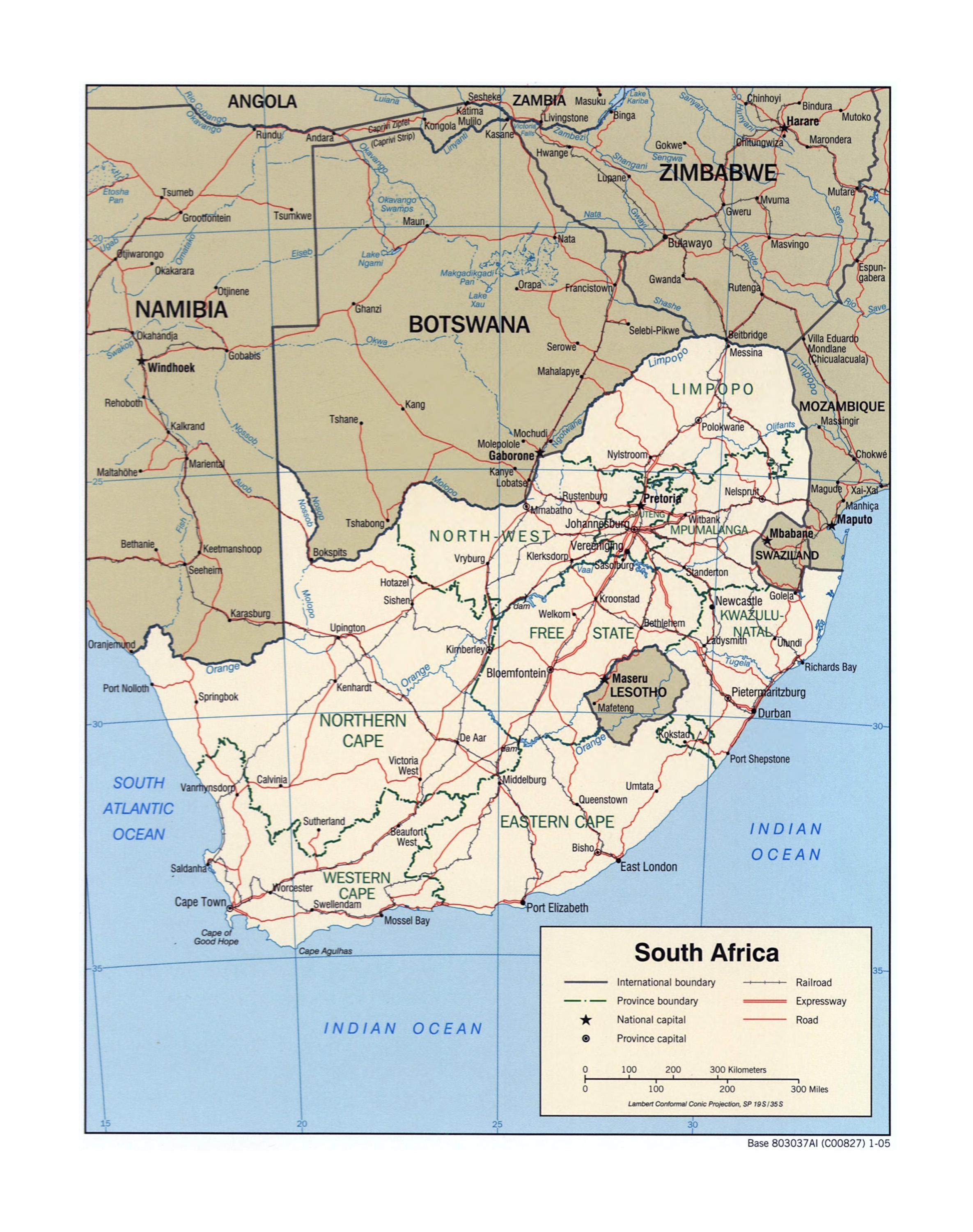
The map of South Africa with major cities shows all biggest and main towns of South Africa. This map of major cities of South Africa will allow you to easily find the big city where you want to travel in South Africa in Africa. The South Africa major cities map is downloadable in PDF, printable and free.
Nearly half of the population lives in urban areas such as Johannesburg, Durban, Pretoria, Cape Town and Port Elizabeth. These major cities have long been the most populated in South Africa and until 1994 the province of Gauteng in specific, was the most populated as its shown in the map of South Africa with major cities. The province of Gauteng includes cities of Pretoria, Johannesburg and the mining region of Witwaterstrand. In general, the eastern half of the country is more densely populated than the western half because of the aridity of much of the west and the concentration of minerals in the east.
Johannesburg is the largest city in South Africa. It is located in Gauteng Province with 7,860,781 people living in its metropolitan area as its mentioned in the map of South Africa with major cities. It houses South Africa constitutional court, and it is a major finance center in the country. Cape Town is a beautiful coastal city in South Africa that is full of life and energy, and has a population of 3,740,026 people. Cape Town is the seat of the National Parliament or the Legislative capital of the country. The residents are of the different racial makeup of Black African, colored, Indians, and whites, all across the city and the suburbs. Durban is the major city in the kwaZulu-Natal province of South Africa, and has a population of 3,442,361 people, making it almost the same size as Cape Town, though with a different collection of ethnic groups living in the city. Durban is well known for its busiest port in South Africa.
Ethekwini is technically what is known as a "metropolitan municipality" in South Africa. Ethekwini includes the sizeable cities of Durban, Umlazi, Chatsworth, and Kwa-Mashu as youcan see in the map of South Africa with major cities. Like Ethekwini, Ekurhuleni is also a metropolitan municipality. The major cities within Ekurhuleni are Katlehong, Tembisa, and Boksburg. Tshwane is a metropolitan municipality in South Africa. When combined, all of its cities amount to make it the fifth largest city in the country.

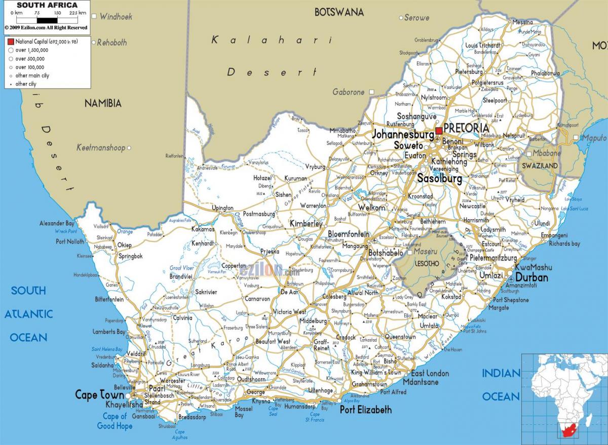
The capital of South Africa map shows the main city of South Africa. This capital map of South Africa will allow you to easily plan your travel in the capital of the country South Africa in Africa. The capital of South Africa map is downloadable in PDF, printable and free.
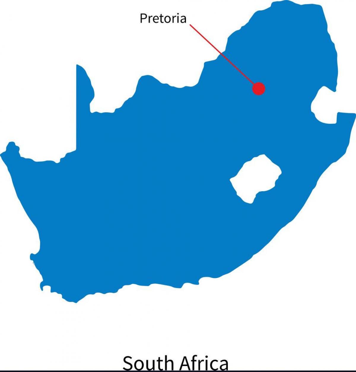
Pretoria is a city located in the northern part of Gauteng Province, South Africa. It is one of the country three capital cities, serving as the executive (administrative) and de facto national capital; the others are Cape Town, the legislative capital, and Bloemfontein, the judicial capital. It became the capital of the South African Republic (ZAR) on 1 May 1860 as its shown in the Capital of South Africa map. The founding of Pretoria as the capital of the South African Republic can be seen as marking the end of the Boers settlement movements of the Great Trek.
Bloemfontein (play /ˈblʊmfɒnteɪn/, Dutch for "fountain of flowers" – lit., "blooms") is the capital city of the Free State Province of South Africa; and, as the judicial capital of the nation, one of South Africa three national capitals – the other two being Cape Town, the legislative capital, and Pretoria, the administrative capital. From 1902–1910 it served as the capital of the Orange River Colony as its mentioned in the Capital of South Africa map and since that time as the provincial capital of the Free State. In 1910 it became the Judicial capital of the Union of South Africa.
Cape Town (Afrikaans: Kaapstad; Xhosa: iKapa) is the second-most populous city in South Africa, and the provincial capital and primate city of the Western Cape. As the seat of the National Parliament, it is also the legislative capital of the country. The city was named the World Design Capital for 2014 by the International Council of Societies of Industrial Design as you can see in the Capital of South Africa map. It became the capital of the newly formed Cape Colony, whose territory expanded very substantially through the 1800s.